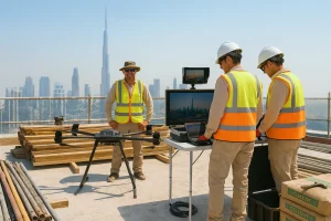
As the fast-changing world of construction, engineering, and land development continues to rise in the contemporary world, no concern is greater than accuracy and speed. The conventional topographic survey techniques might be dependable, but increasingly they are supplemented in significant cases made obsolete by increased accuracy, efficiency, and enhanced safety enabled by drone technology. At Drone Film Arabia, we excel at employing the state-of-the-art drone solution to provide excellence-defining topographic surveys.
What is a Topographic Survey?
A topographic survey maps the natural and man-made features of a land surface, such as terrain and elevation. It requires data for environmental works, planning, and building. The traditional process is precise but labor-intensive and time-consuming and entails backbreaking work in extreme conditions.
Role of Drones in Topographic Surveys
Drones, or Unmanned Aerial Vehicles (UAVs), have revolutionized topographic surveying into a quick, safe, and affordable process with the technology provided by the utilization of high-resolution cameras, LiDAR sensors, and sophisticated GPS systems. They are able to record aerial photography and geospatial information in broad areas at an extremely rapid rate with minimal human interaction.
We at Drone Film Arabia use state-of-the-art UAVs that are powered by Real-Time Kinematic (RTK) and Post-Processing Kinematic (PPK) GPS systems. These allow positional accuracy of centimetres, making drone-based surveys equivalent to ground surveys but requiring much less effort. The data collected is then used to create accurate 3D terrain models; digital elevation models (DEMs), orthomosaic maps, and other required outputs for planning and analysis.
Key Benefits of Drone-Based Topographic Surveys
1. Exceptional Precision
Surveys by drone with RTK and PPK systems can offer horizontal precision to 1 cm and vertical precision within 3 cm in ideal conditions. High-resolution images and accurate GPS data allow high-quality topographic maps to be highly accurate enough to be used by professional design and engineering applications.
2. Unmatched Efficiency
Drones slash the time it takes for data collected significantly. An activity that may take days or weeks for a conventional survey team may be accomplished sometimes within hours using drones, though. This enhanced speed speeds up projects’ timelines, enhances responsiveness, and supports faster decision-making.
3. Cost-Effective Operations
Drone filming services minimize the requirements for large field users and costly ground equipment. Streamlined production, from data capture to processing, means substantial savings. Clients get rapid turnaround at reduced operating costs without compromising data quality.
4. Enhanced Safety
Surveillance of rough, far, or danger-prone sites like rugged slopes, under-construction zones, or factories exposes workers to danger. Drones rule out direct access to the site, acquiring all the relevant data from a distance. It makes workers safer and reduces project managers’ liability.
5. Extensive Industrial Applications
Drones can be used for wide-ranging industrial purposes, which can be customized as per various sectors:
- Construction & Infrastructure: Drone construction monitoring helps Track work, design site plans, and coordinate earthworks.
- Agriculture: Scanning soil condition, crop health, and irrigating.
- Mining & Quarrying: Volumetric estimation and site environmental impact measurement.
- Urban Planning: Generating high-resolution base maps for development and zoning.
- Environmental Studies: Monitoring land use change, erosion measurement, and habitat assessments.
Also Read>>Top Benefits of Using Drone Services for Businesses in 2025
Why Choose Drone Film Arabia?
At Drone Film Arabia, we are proud to be pioneers in drone surveying technology. Our crew is composed of licensed drone pilots, GIS experts, and surveying professionals who are committed to delivering reliable, high-quality data for smart project planning.
We invest in cutting-edge drone equipment and processing software to provide our customers with actionable and reliable information. From building infrastructure to asset land management to environmental surveys, we craft our solutions to your specific needs.
We distinguish ourselves by having a focus on:
- Accuracy: Utilizing RTK/PPK drones and sensor-calibrated sensors.
- Speed: Streamlined workflows that prevent delays.
- Client Collaboration: Open communication and tailored deliverables.
- Compliance: Respect of national and international UAV legislation.
Summary:
Drones have revolutionized the process of topographic surveys, and they are now quicker and more precise. We use the most advanced drone technology here at Drone Film Arabia to provide precise and clean land data. Our work is safer, quicker, and cheaper than conventional methods. More projects are requiring precise land data, and drone surveys are the intelligent choice. Call Drone Film Arabia today to learn how we can assist your next project.